
****This station is located in the French Quarter park****
include("nws-alerts.php");
 Follow @westweather716
| |||||||||||||||||||||||||||||||||||||||||||||||||||||||||||||||||||||||||||||||||||||||||||||||||||||||||||||||||||||||||||||||||||||||||||||||||||||||||||||||||||||||||||||||||||||||||||||||||||||||||||||||||||||||||||||||||||||||||||||||||||||||||||||||||||||||||||||||||||||||||||||||||||||||
55°F
Today is Monday,
Data From A Personal Weather Station In West Seneca,NY
Data From A Personal Weather Station In West Seneca,NY
Updated:
29-Dec-2025 2:15am

NAVIGATION
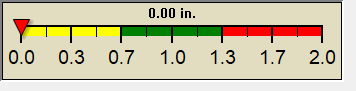
24 HOUR SNOWFALL
STATE EXTREMES
High Temperature
70°F at El Centro Naf, CA
Low Temperature
2°F at Bridgeport Sonora Junction, CA
High Precipatation
0.21in at Blue Canyon Nyack Ap, CA
Data courtesy of NWS-CPC
USA EXTREMES
High Temperature
96°F at Alpha (balfour), ND
Low Temperature
-18°F at Presque Isle Awos, ME
High Precipatation
0.74in at Minot Afb, ND
Data courtesy of NWS-CPC
Alerts
Affiliations

 --------------------
 --------------------
 716-503-ANDY
--------------------
716-503-ANDY
--------------------

Style Options