
****This station is located in the French Quarter park****
include("nws-alerts.php");
 Follow @westweather716
| ||||||||||||||||||||||||||||||||||||||||||||||||||||||||||||||||||||||||||||||||||||||||||||||||||||||||||||||||||||||||||||||||||||||||||||||||||||||||||||||||||||||||||||||||||||||||||||||||||||||||||||||||||||||||||||||||||||||||||||||||||||||||||||||||||||||||||||||||||||||||||||
75°F
Today is Friday,
Data From A Personal Weather Station In West Seneca,NY
Data From A Personal Weather Station In West Seneca,NY
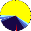
Updated:
18-Jul-2025 7:20pm

NAVIGATION
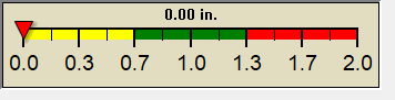
24 HOUR SNOWFALL
STATE EXTREMES
High Temperature
106°F at Needles, CA
106°F at Palm Springs Asos, CA
Low Temperature
41°F at Bridgeport Sonora Junction, CA
41°F at Truckee Airport, CA
High Precipatation
none
Data courtesy of NWS-CPC
USA EXTREMES
High Temperature
106°F at Needles, CA
106°F at Laughlin Bullhead Intl Ap, AZ
106°F at Las Vegas Nellis Afb, NV
106°F at Palm Springs Asos, CA
Low Temperature
35°F at Angel Fire Airport, NM
High Precipatation
4.55in at Manitowoc, WI
Data courtesy of NWS-CPC
Alerts
Affiliations

 --------------------
 --------------------
 716-503-ANDY
--------------------
716-503-ANDY
--------------------