
****This station is located in the French Quarter park****
include("nws-alerts.php");
 Follow @westweather716
| |||||||||||||||||||||||||||||||||||||||||||||||||||||||||||||||||||||||||||||||||||||||||||||||||||||||||||||||||||||||||||||||||||||||||||||||||||||||||||||||||||||||||||||||||||||||||||||||||||||||||||||||||||||||||||||||||||||||||||||||||||||||||||||||||||||||||||||||||||||||||||||||
55°F
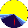
Updated:
27-Jul-2024 4:40am

NAVIGATION
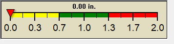
24 HOUR SNOWFALL
STATE EXTREMES
High Temperature
120°F at Palm Springs Asos, CA
Low Temperature
45°F at Fritzsche Aaf, CA
High Precipatation
0.17in at Vandenberg Afb Lompoc, CA
Data courtesy of NWS-CPC
USA EXTREMES
High Temperature
120°F at Palm Springs Asos, CA
Low Temperature
37°F at Leadville, CO
High Precipatation
2.12in at Palacios Municipal Ap, TX
Data courtesy of NWS-CPC
Alerts
Affiliations
 --------------------
 --------------------
 716-503-ANDY
Find Lost Dogs