
****This station is located in the French Quarter park****
include("nws-alerts.php");
 Follow @westweather716
| ||||||||||||||||||||||||||||||||||||||||||||||||||||||||||||||||||||||||||||||||||||||||||||||||||||||||||||||||||||||||||||||||||||||||||||||||||||||||||||||||||||||||||||||||||||||||||||||||||||||||||||||||||||||||||||||||||||||||||||||||||||||||||||||||||||||||||||||||||||||||||||||||||||
39°F
Today is Wednesday,
Data From A Personal Weather Station In West Seneca,NY
Data From A Personal Weather Station In West Seneca,NY
Updated:
17-Dec-2025 11:00am

NAVIGATION
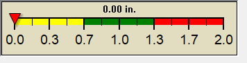
24 HOUR SNOWFALL
STATE EXTREMES
High Temperature
88°F at Palm Springs Asos, CA
Low Temperature
12°F at Mammoth Lakes Mammoth Yosemite Ap, CA
High Precipatation
1.17in at Crescent City Mcnamara Ap, CA
Data courtesy of NWS-CPC
USA EXTREMES
High Temperature
88°F at Palm Springs Asos, CA
Low Temperature
-15°F at Mount Washington, NH
High Precipatation
2.76in at Shelton Ap, WA
Data courtesy of NWS-CPC
Alerts
Affiliations

 --------------------
 --------------------
 716-503-ANDY
--------------------
716-503-ANDY
--------------------

Style Options